wxrisk.com

Thursday, November 30, 2006

" DEFLECTORS just snapped on Kep' tin..." as 12z GFS jumps in bed with 0z ECMWF

Well the move is now done and over with... but it's not been a loss of just the last three days. The actual time spent in searching for new place and all the other things that one must do when making a major relocation like this... is a lot mo than three days . I ended up losing a lot of free time for the month November. This is free time which I planned to use to for some special projects including a complete revamping of the snowstorm checklist. Now that things to settle down little bit I will have to bust some serious fanny to get the checklist up ands running with a snow event possibly looming on the East Coast with the first significant to storm December 7 -- 8.

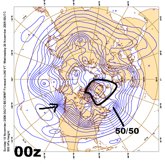
The first image I'm presenting is an approximate representation of the 204 hour 0z ECMWF. I made this this map from my copy of the 204 hr with my Microsoft image composer. As you can see them all clearly shows very strong shortwave move into the Tennessee Valley and significant call their damning. Note that the 1044 arctic HIGH we see in the western portions of the Upper Plains at day 6-7 ... has extended a "neck" into the Great Lakes & New England as this system approaches the East Coast. The signature is very clear for CAD.
http://www.wxrisk.com/MODELFOLDERS/today/bgh1.jpg


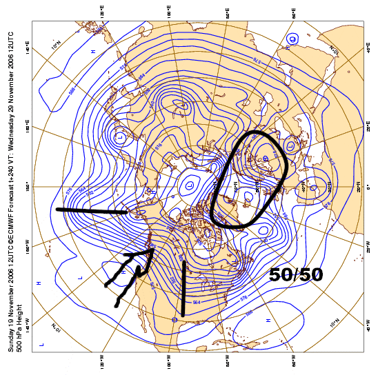
These next two maps are from the 12z Thursday GFS. This image shows the 500 MB shortwave move into the Tennessee Valley and then across the middle Atlantic states at 180... 192... and 204 hrs. Note that the shortwave is positively tilted but does turn to Neutral tilt at the coast and that the Vort Max travels in a due West East direction across the state of Virginia. It does not turn to the northeast and of course neither does the 850 low or the surface Low. The reason for this is that the midday GFS sees another system upstream which is acting as a Kicker forcing this system to slide East off the coast.
http://www.wxrisk.com/MODELFOLDERS/today/COMP.jpg

Next image is the 850 Low track with the RED dot the approximate position of 850 low. And as you can see this is a great track for Northern Virginia Maryland Southern Pennsylvania New Jersey and perhaps as far north as New York City and Southern Long Island but that's assuming that it stays cold at all levels of atmosphere. Again note how the model does not turn the system up the coast but essentially tracks it off in a due easterly direction.
http://www.wxrisk.com/MODELFOLDERS/today/COMP1.jpg

Now I'm not saying that the midday Thursday GFS is correct that simply with the model showing.

That being said there are some things to talk about. First the arctic HIGH that comes down from western Canada into the Plains and Midwest is an impressive 10044 MB HIGH The climo of significant or major East Coast snowstorms is such that large arctic High pressure systems such as the one we are going to see tend to favor East Coast Low-pressure development. Second the reason why we do not keep cold air in place is because of the unfavorable pattern we have 500 mb over eastern Canada and Greenland. This is a textbook case for all you out there to understand why the upper air patterns over North America are so vital keeping a ALL snow event the Northeast corner. In this case we don't have the features that we want to see typically look with all snow event. According to the model and again this is just the best early guess ... there is no 50/ 50 low over or near Newfoundland Canada. There is no high Lat blocking over Northeastern Canada or Greenland.

Because of this lack unfavorable upper-level pattern over eastern Canada and Greenland to large arctic High and its neck that extends into England breaks down as the secondary Low develops on the Northeast coast of North Carolina. This allows a southeast wind to develop until the coastal Low finally kicks and thus the changeover to rain along the I-95 Corridor from Richmond all the way to NYC.

Now all this means is that the odds are not favorable for an all snow event for the I-95 big cities but it's quite possible that is this set up that the big cities could see significant snow before changes over and given the fact as early December one should not look a gifted worsen the mouth.

update coming at 11am Yes D8-9 0z Euro shows MECS THEN pattern collapses

Hello from N ashburn VA... just 4 .25 miles from Lessburg airport ... yes folks I have seen the op 0z Thurs ecmwf and its MECL-- miller B ( major east coast low) which for some could be a snowstorm especially over interior N Mid Atlantic and New England... whatbis very impressive is the 1044 MB high that Necks east of the Great lakes and gives off clear CCAD signature ..

more later getting caught up with paying clients... i saw yesterday that one of my competitors in Happy Valley PA... wich was pushign the New Orelans Nantucket track from 11/26 FINALLY gave up on the siliness ... of course to over compensate for this busted frorecast and wish coast he then went extreme the OTHER way... calling the Midwest Low now developing over ARK will be one of the biggest if not the biggest pre xmas Midwest snowstorms ever..

NOT....

southside chicagao will see best snow as well as SW chicago over towards La Salle and Quincy and St Louis... wet ground and warm temps do not make for HUGE massive snowstorm totals.... i saw one weenie over at eastern issue a professional map calling for a stripe of like 10-20 inches for Chicago... Come on folks Get a fooking clue

after the dec 8 -9 event the +Pna will breakdown.... for a while.

Wednesday, November 29, 2006

12z WED models support the Big Midwest Low/ snow WHAT ABOIUT 1ST SECS 12/4-5???

busy moving in today...but 12z NAM and GFS bomb STL MO western ILL and ORD with good heavy snows.... and makes me look good

6'' seem likely could be more ( up to 12 inches) but for one its warm now and transitioning to cold and the ground will be wet.... Big winners QUINCY ILL along with GALESBURG ILL JACKSONSVILLE ILL PEORIA ILL into DeKALB JOILET and maybe Chicago

12z GFS show arctic blast #2 much like the 0Z ecmwf did at DEC 6-7
NOTE THE 1044 HIGH

http://www.nco.ncep.noaa.gov/pmb/nwprod/analysis/namer/gfs/12/images/gfs_slp_096l.gif

THE 12Z AT 120 hrs shows wave development off NC coast... model might be too flat so it could be closet and does bare watching

lastly yes thanks for all the great comments about this blog.... as to the question why couldnt I be like this at eastern?

two reasons one I am not trolled here.... so I dont have anything to respond TO.... and second maybe the question should be why couldnt eastern be more lke this blog with respect to me?

Tuesday, November 28, 2006

6z GFS is CRAP; Its a true Midwest Chicago snowstorm + PNA looks to hold

not much time today.... first off the 00z ECMWF and GFS are in GREAT agreement on signfificant Midwest snowstorm coming with central and Northern ILL into estern MI seeing 6 or more inches of snow this weekend but the 6z GFS takes it all away.

lets be clear before some of you east coast or bust assholes cackle with villaneous glee -- the 6z GFS is bullshit and anyine with a brain can see it. The GFS says there is NO huge ridge over SE`coast. The 6z GFS model says in 60 hrs that ridge will be gone....

so I am going to hit 70 today and wed b/c of what then? The Klingons firing theot warp engines? The one thing we do KNOW about the next 3-4 days is that the SE ridge is strong and a fghter which means the s/w over TX / eastern OK and or the western Delta will be forced to travel NE along the and over the Ridge as the ridge slowly slies east.

This is a TEXT book case of why a NEGATIVE NAO is sooooooo important in he set up for a SECS/ HECS / MECS

look at the over whelming data

84 hr 500 MB 0z GFS
http://www.nco.ncep.noaa.gov/pmb/nwprod/analysis/namer/gfs/00/images/gfs_500_084s.gif
72-96 hrs 0z ukmet
http://meteocentre.com/models/ukmet_amer_00/ukmet_00_panel.gif

72-96 hr ecmwf
http://meteocentre.com/models/ecmwf_amer_00/cep00_9panel.gif

and the ENSEMBLES at 84 hrs almost every one of them have intense closed 500 Low over far eastern MO or downstate ILL or IND.... pay attention to C000 P001 P002 P003 P005 P006 P007 P008 AND P10

versus this BS....

84 hr 500 mb 6z GFS
http://www.nco.ncep.noaa.gov/pmb/nwprod/analysis/namer/gfs/06/images/gfs_500_084s.gif

ITS NOT EVEN CLOSE ... The 6z GFS is a Bogus run....

lastly remeeber all those pronouncement ( i was readings some of the older posts ver the weel at eastern) on how this cold blast in early DEC is NOT going to last and the Pacific Jet would break through and how dec would be mild?

they dont look too good right do they?

Monday, November 27, 2006

If you get the eastern Pacifc and Pac NW wrong you got NOTHING!!!...

I cannot spend as much time posting on the medium and long-range forecasts as I wish to as the next two- three days because I am in transit and moving the up to Northern Virginia. So the posts will kinda be a short side of... but I still should be able to cover all the major points.

One of things that you will notice in this web site and on this blog is that I try not to favor anyone particular region of the country. I do this for number reasons but one of the fundamental principles that I was taught early on as an undergrad was that If you cannot forecasts the Pacific Northwest & western Canada correctly thing you've got nothing. You got Bupkis... and any medium-range forecasts that you make in going to up in the crapper.

A classic example of this is the current pattern change which is going to occur this week across the Conus. Back on November 15 --16 when I started banging the drum about this probability of some sort of pattern change and then later on a significant pattern change ... I THINK I was the only doing so at THAT time ( but I might be wrong about that) . I do know that my early call of this possibility was greeted by a great deal skepticism in the usual weather forums. The reason I think this is not because it's DT.... since I had a reputation for NOT jump the gun and NOT gong for the hype... until I feel there is considerable amount of evidence... but because a lot of forecasters had misread what was going on Eastern Pacific.

This is a repeat in some ways of what went on Last winter. I am sure I don't have to remind you that the consensus forecast from a lot of well-known private forecast services was for a cold and stormy winter 2005-06 over the eastern US. There is very low emphasis outside of my self from any other forecaster that I know about the power of the Pacific Jet last winter enhanced by a persistently Postive EPO and the very neg QBO. IMO this is why most of the winter forecasts for a cold and /or stormy eastern US busted so badly.

This time around they seem to be this general except in said the Pacific Janet El Nino enahnced was gone keep on firing right to most of December and not really let up until either the middle portion of December or perhaps until after the holidays. Well if that is your assumption then you may be about to lose the game so let me buzz you out ... and say thanks for playing Johnny can you tell us what he's won as a consolation prize!?.....


The 0z and 12z data are very strong both the operational and the ensembles in showing that the +PNA is going to last through the first week of December may be to December 10-11... then after that who knows?? . Perhaps you don't know but let me remind you that the important SSTA in ENSO region 3.4 did NOT rise today...it held at +1.3c. If the El Nino is moving towards a moderate ENSO event if only for a few weeks... the idea that we can now turn cold across North America especially east to the Rockies for a 7-10 day period is VERY significant.

If we take a closer look at some of the details here... there is little doubt my mind now that the significant Low which develops over the Eastern US on December 1-- an event which I started talking about back on November 16-- is going to be a Midwest snowstorm. In particular the 12z GFS UKMET and ECMWF all show this wave developing from the Delta tracking NE towards southeast Ohio and perhaps up near Erie PA or western York state... although the midday European takes it will further west... very close to Detroit. Given again the Autumn pattern -- see my winter forecast -- that has already seen 4 or 5 significant Midwest Lows this sort of track really should NOT be a point of controversy.

Of course the usual sources of hype are trying to insist that somehow this pattern COULD possibly shift this Low towards East Coast blah blah blah. But don't you fall for that BS. In this ... moving from an extremely warm pattrern with the huge Ridge in the southeast towards a +PNA and + NAO... well you can say with a great deal of confidence that this is not an East coast track or even a inland East Coast threat.

Both 12z runs of the operational European and GFS at midday are very impressive with the 2nd Arctic air mass which comes down from western Canada into the Plains & Midwest... and to lessor degree into the East Coast.

Let me emphasize again one other point... which is a really important one not only for those who are trying to practice and learn synoptic meteorology but also those who are trying to trade energy markets. As I stated in the Winter forecast... In a week to moderate El Niño pattern the GFS in particular has a heavy bias to constantly breaking down any sort of cold pattern in the 11-15 day and the developing some sort trough on the West Coast. Sometimes this is going to be the correct way to go but a lot of times the operational GFS is going to be the outlier even against its own ensembles. This is going to result in a lot of folks killing the cold pattern prematurely and going to blow torch for the Week 2 forecast. ......"Oh sure it's going to cold for a few days but next week...man Look at that blowtorch... "

folks who make that sort of flippant and shallow remark really don't have a clue what the hell they are talking about.

The case in point is this current cold shot coming up in the 6-10 day. If you recall the 6-10 day from last week as well as the 11-15 day from last week... from the various private weather services as well as CPC... NONE had cold in the Eastern US. None .... why ? Because the operational GFS screwed up the Eastern Pacific and especially many the ensembles continued to show constant Pacific flow. Then as we got closer to D10 the pattern began to look like colder and more sustain cold. This is going to be a problem all winter especially the first half of season. Let this be a lesson to you and don't forget this Model tendency and you will do all right the rest of season.

Sunday, November 26, 2006

The +PNA cometh !!!!

Looking at the data in the overnight hours and early this morning it appears that I have become a WEATHER GOD. OK.... OK..... I don't really mean that but what I am trying to drive home is the idea that the significant pattern change I have been banging on at the end of the month is real . I think its clear to all now that from looking at all the data that not only is this warm pattern about to come to an end but there is increasing amount of data that shows were moving into a +PNA.


To be sure when I first post to this idea back over Nov 15 - 16 it was greated with a lot of shall we say "Negative" comments and feedback at some of the weather forums where I occasionally post. Well I don't think those folks still hold the same view!!!!!... and if they do they probably should well get out of weather business and go sell some shoes.

There is of course debate as to how long the +PNA is going to last or If the +PNA is going to be a split flow... with the southern branch coming into say California and the northern branch showing the Ridging over western Canada. But again it's time to face reality... Winter is coming so enjoy this spectacular weather while you can.

the 0z Sunday GFS at 132 and 144 hrs showed one of the most impressive cold fronts I have seen a longtime. The 850 temps at 132 hrs -- the morning of 12/1-- RIC +13C DCA +12 NYC +11 BOS +10 ALB +9... yet 12 hours later RIC drops to -3c DCA-9c NYC -8c BOS -6c and ALB -9c
http://weather.unisys.com/gfsx/5e/gfsx_850_5e.html
http://weather.unisys.com/gfsx/6d/gfsx_850_6d.html

Bloody hell... now that's a cold front!!

The other issue of concern I have expressed many times here as well as some other places is that some sort will wave of Low pressure is going to develop on the front as the southern end of it comes slows down significantly DEC 1.

The 0z Euro show this wave developing over the TN valley and bringing a early-season snowstorm to portions of the Midwest and this is now supported by the 6z GFS. Recall the rule I mentioned in a previous posting here that whenever the 6z GFS and 0z Euro agree it is always a good sign that the 0z Euro run is correct. Of course such a wave of Low pressure would delay the Arctic front at least another 12 hours until it passes through the East Coast.
http://www.meteo.psu.edu/~gadomski/ECMWF_0z/f120.gif
http://www.meteo.psu.edu/~gadomski/ECMWF_0z/f144.gif
http://www.meteo.psu.edu/~gadomski/ECMWF_0z/f168.gif

6z GFS 500 MB
http://www.nco.ncep.noaa.gov/pmb/nwprod/analysis/namer/gfs/06/images/gfs_500_132m.gif
surface map
http://www.nco.ncep.noaa.gov/pmb/nwprod/analysis/namer/gfs/06/images/gfs_slp_132m.gif


Here is the mean pattern taken from the Penn State e-wall site for Day 8-10 at 500 MB... for the 0z operational ECMWF and the 0z GFS. Again we can see clear indications on a full power classic +PNA. Of course the 0Z GFS-- map on the right side -- is not THAT impressive because it closes off a Low at 500 MB over the southwest US but as I already stated the 6z GFS does not show this feature and is very close to the operational European..
http://www.meteo.psu.edu/~gadomski/ECMWF_0z/hgtcomp.html


In addition you can see this for yourself by taking a look at the ensembles runs of the 0z GFS. As you can see a few members to hang back a LITTLE piece of energy or bend in the Jet stream over the southwest states but NONE ( not one!!!) of the 11 members show closed off Low over the SW states. Therefore the data is overwhelming that idea of the closed 500 Low over the southwest US as depicted by the 0z GFS to be BS.
http://www.meteo.psu.edu/~gadomski/ENSHGT_0z/f240.html


We can also see that by taking a look at the 240 hr Canadian and GFS ensembles Mean maps. The map in the upper left corner shows the operational GFS and again note the closed 500 Low over the southwest. However the bottom left map which is the GFS ensembles mean at day 10 clearly shows a classic +PNA as does the 0z CMC ensembles mean ( bottom right).
http://www.meteo.psu.edu/~gadomski/NAEFSHGT_0z/f240.gif


Again let me emphasized that I am not forecasting the coldest air mass of all time or anything close to historic levels or even SIGNIFICANT cold oubreak (yet) . My point is that the pattern shifting and showing signs moving into a early December 1 run of the mill Winter pattern. To be sure there is no reason to start running specials on the god awful Weather Channel (one day I have have a post about TWC and what a wretched place that has become) just yet but in my opinion any time a Winter pattern develops in El Niño year is always a good sign since there been many El Niño Winters where thehre has never been a sustained Winter pattern that has locked in place. Of course I don't know if the new pattern is going to "lock in" or last seven days and then collapse.

A case can be made for either scenario at this point I just don't know but it's nice to see this pattern developed if you are Winter lover as opposed to what we have seen for much of NOV.

Friday, November 24, 2006

DONT LOOK AT DAY 8 WHATEVER YOU DO!!! -- LOL....

Well that was a pretty good Thanksgiving and I dont telling you I thoroughly enjoyed the Noreaster... along with the usual traditional dinner. This of course is the last Thanksgiving on I am going to be spending here in Chesterfield Virginia. This house has a lot of meaning for me ... my son was born in this house... grew up through Toddler hood and now as a 9 year old and in this house I started this business and web site here in the basement which is my home office. And while the new location surely is nicer it takes a while for it becomes home... but isn't that always the case when you move?

Before I get into the actual forecasting here this morning I wanted to make a couple of brief comments. First in my little humorous blurb I made in the previous posting about having the wrong attitude with regard to altering a forecast... I may have stepped on a few toes accidentally. There are a lot of meteorologists in the private sector who have that mentality of not changing the forecast until actually busts. It is not just a NWS mentality. In fact I know a lot of forecasters in and of US who do change the forecast when it is needed especially is the short-range. Really all I was attempting to do to make the a point was taking it to the Nth degree. No offense intended.

Second... there seems to be this perception out there that regarding the debate on how warm the winter it is or is not going to be ... and that it is aimed at one particular person or perhaps just a few people. Well that really isn't so. There are a lot of private forecasters both on their own and within Energy and at the Agricultural companies which are forecasting a pretty mild winter. The forecasters over at Sempra trading and Telsa forecasting and some folks over at Citadel... are all in the warm winter boast ( just to name a few). This friendly discussion and debate is not really aimed at any one particular person. For me it is an intellectual exercise to see if the techniques and ideas which I've used over the last several winters actually has a some sort of validity or perhaps that I am just lucky and I'm really just full of Bravo Sierra.
OK let's move on to the weather. As many of you know I've been forecasting a pattern change to occur at the month into early December (since Mid NOV) as well as the potential for some sort of significant event over the eastern US. Not necessarily an East Coast event but some sort of significant low as a possibility on 11/20- 12/1. Of course it might be more likely send the second but that's the general idea.

In case you did not see the European model over the last couple of runs I am presenting the date 10 European from 0z Thurday then 12z Thurs and 00z Friday.

http://wxrisk.com/MODELFOLDERS/today/NOV24/0Znov23D10.gif

http://wxrisk.com/MODELFOLDERS/today/NOV24/12zNov23D10.gif

http://wxrisk.com/MODELFOLDERS/today/NOV24/0Znov24D10.gif

As you can see each warm the solutions are significantly different from the other... with the first map being the coldest. I am not really forecasting some sort of bitter arctic outbreak percentage or the coldest air mass in several years or anything like that. My whole argument here is that the pattern which is dominated Noth America for November... which has featured a deep Vortex over the eastern Gulf of Alaska near the British Columbia / Alaska Panhandle Coast... is going to break down and this result in a more seasonal early December pattern. Not historic cold... Not severe cold... Not exceptional cold just seasonal. Even though there is a wide variety of solutions on many of these medium-range models by date 10 which is to be expected in aweak El Nino pattern the one thing that we can see is that very few of the models or in some old members are still showing a deep for tax in the Eastern Gulf Alaska. Some depict a strong+PNA... some a weak +PNA... some with a split flow. But from what I can see very few if any are still showing the powerful Vortex on or just off the West Coast Canada by DEC 1


Of course with all the energy initially going into the Rockies & the Great Basin... the Ridge over the eastern third of US is going to strengthen dramatically and I would not be surprised if Chicago got close to 70° Tuesday afternoon. Interestingly although the Ridge over the SE states looks very strong the actual cold front does not really slow down and makes pretty steady progress day 5-6-7.

Of course the overnight European model at D7-8 as well as the 0z GFS and 6z GFS are trying to develop some sort of coastal low on the front. Given the matter of cold air which is going to be pouring in rapidly behind this front and the fact that that the front might stall just after it clears the East coast the development of this coastal Low is a very interesting feature indeed.

http://wxrisk.com/MODELFOLDERS/today/NOV24/12zNov24D7.gif

http://wxrisk.com/MODELFOLDERS/today/NOV24/12zNov24D8.gif

http://www.nco.ncep.noaa.gov/pmb/nwprod/analysis/namer/gfs/00/fp0_192.shtml

http://www.nco.ncep.noaa.gov/pmb/nwprod/analysis/namer/gfs/06/fp0_192.shtml


If this was the middle of Winter there would be a lot of snow talk going around the various when the communities for next DEC 2. To be sure given the fact that the seasonal trend has supported so many coastal Low pressure areas this season it would be foolish to completely dismiss the idea of a coastal Low developing on the base of the trough December 1-2. It is early but I am not going to dismiss the idea and there is some support from the various GFS ensembles for this sort of scenario as well. The problem is of course that the cold air has be in place as soons as the front passes... it still eight days out ... and an awful lot can go wrong. It is not an ideal pattern for any sort of winter threat for the East Coast... and everything past fall in place just exactly right for something like us to occur.

By D10 you can see many of ensembles are showing some activity with respect to strong short waves of dropping through the Gulf Alaska headed towards British Columbia / Pacific Northwest there are no members that show a deep vortex STILL situated in the Gulf Alaska. None.

http://wxrisk.com/MODELFOLDERS/today/NOV24/f240.gif

http://wxrisk.com/MODELFOLDERS/today/NOV24/gz.1124.240.gif


By 288 hrs 12/6 things look a lot more interesting. C001 which is the Operational 0z GFS looks pretty benign when you compare it to some of the other members such as C000 (wow) p001 p003 p004 p008 p009 p010 and P011 (wow). This is not enough support from the various ensembles in my opinion to get "excited" about some possible event on December 6 but it is something to look at.
http://wxrisk.com/MODELFOLDERS/today/NOV24/f288.gif

Wednesday, November 22, 2006

WED AFTERNOON COMMENTS

While the e-mail is flowing fast and furious as more and more folks realize that this blog will be updated regualrly and it gets out there into the meteorological and weather hobbyist communities.

I am in the mist of a major overhaul of the snowstorm checklist and when it is done-- I hope by around December 1-- it should be the most comprehensive and arguably enjoyable thing for snowstorm lovers in the Northeast US to go to a regular basis during the cold season months. By the time is all said and done it will stun you with its comprehensiveness and I hope its ease-of-use. It's something I have always wanted to do but never had the time but now is the business doing so well I can cut back on some are other activities and make this snowstorm checklist the thing of beauty I've always wanted it to become.

As far as the midday stuff goes obviously the midday GFS has come about with a totally different solution than what the last several runs were showing with regard to the pattern shifting next week and the development of the deep trough over the East Coast. I don't consider the this 12a GFS run to be a viable solution as it has a far too much energy in the southwest US where it develops that huge upper Low over the Great Plains and Rockies which results in that blizzard that moves into the Upper Plains. Of course with that huge trough over the Rockies the Ridge over the Midwest becomes very strong... and the cold front is delayed significantly. But the time it reaches the East Coast the trough is a shadow but what they model was showing at6z and 0z .... as a result the cold air is essentially gone.

The midday European has a similar solution but not quite as extreme... and when the trough does reach the East Coast its still has a fairly strong amplitude with it and there is still quite of cold air. In fact the operational European stalls the front in a SSW to NNE alignment from Georgia to Cape Cod day 9.5 and day 10 with a very impressive temperature gradient over the middle Atlantic states....

The GFS ensembles on this Wednesday afternoon are not supportive of the operational run and have a lot more amplitude in the eastern trough at D8-9

Interestingly by D9-10 the 2z operational European shows the Pacific jet has split up into THREE distinct branches along the West Coast in North America. I will put this map up on the Modeltracker page later. IF that is correct and I don't know that it... then the patetrn COULD hold some promise for December across the central and eastern US with regard to seeing at least normal temperatures and still quite a storminess. You see when you have the Jet split put up into 2 or 3 branches they no longer have a uniform flow and it is easier to get the northern branch to buckle or amplify while the southern branch continues to bring in these significant systems from the Pacific. I'm not forecasting such a positive winter scenario development to occur I just think the D9-10 operational European has some promise. That's all just a promise no guarantees.

ANOTHER noreaster!!! what does it Mean ??? .

gobble fooking Gooble ya sick twisted freaks....

I have gotten some emails and coments about how often this Blog with be updated... Good question..once I get settled in to the new place and shift over to my early hours-- where I am up at 530 or 6am I hope to have this Blog updated every days... sometimes Twice a day if the 12z stuff is worthy. In that instance I will do so AFTER the 12z GFS CMC UKMET and Euro have all come out.

Also I will have to figure out what to do with the Modeltracker page as well now that I am running this blog.

The next thing I want to talk about is this perception I see from a lot of undergrad and it exists even in some professional meteorologists that when they issue a forecast .... be it short range... medium-range or long-range or seasonal forecast... that is wrong or somehow the demeaning to change the forecast. OK lets get right ot it... That mindest is crap and if that is your perception as a meteorologist you going to fail in the PRIVATE sector. With that sort attitude / mentality you will probably in the National Weather Service... possibly as a large fat overweight govt employee with your arms sticking out of the sides at a 45° angle still working the Midnight shift at the age of 55 ...when one day your wife tells you she cant take it anymore and is leaving you for the entire Washington Redskins football team and you end up getting a heart attack!!!!

Forecasting is about getting a forecast RIGHT --- it is not about your ego. If you make the forecast and you can see itis busting change the damn thing!!! This is the way it is ( and has to be ) in the private sector and quite frankly it's this attitude that some undergrads and other professional meteorologists (even in the TV business) which cause a lot of tension between meteorologists who deal with the energy and agricultural markets and those who have this weird perception or mindset. I have demonstrated many times on my web site (and other locations) that when I think MY forecast that I originally issued is wrong... I change it. It's a tricky thing to be sure because you don't like change it too early but when it becomes obvious the fastball is about to smack in you face please get bail out... Thank you... this has been a public service annoucment from DT ( aka the Master of Disaster the Commander of Choas ...the Virginia Vigilannte)


I presume by now you have heard or read about the snow which was reported in portions of Georgia & SC yesterday and I have heard but not yet confirmed that there was the snow reported near the GA FL state line. Yesterday afternoon around 3-4 PM hear in the Richmond metro area I personally saw rain mixed with snow which was a pleasant surprise and the temperature was 41 or 42°.

I have emphasized this point several times at some of other forums where I occassionally make weather comments but I have to emphasize it one more time. This is the sixth significant and fourth major coastal LOW we have seen on the East Coast since October 1. Seasonal patterns matter. A lot... sometme the entire seasonal forecasts can be easily detected and picked up on very early and good forecasters can see it. We may be seeing this sort of thing unfold right in front of us. What's amazing about this stormy pattern for the East Coast.... is that we have had these coastal storms when the pattern has been cold in October and mild November. The point is it does NOT make a difference -- you fart too loud in this cold season you are going to get a big storm on East Coast. In case you did not know for central VA Autumn 2006 is now the Wettest Autumn ever and that is exceeding the 1999 season we had Floyd.... and I suspect that when I browse the data I will find similar sorts of records or near record set in many locations across Virginia and North Carolina and probably Maryland as well.

I suppose it's possible the seasonal pattern may break down as soon as we move into winter... I know when I was in undergrad and I was looking at the trend in the autumn of 1987 and looking forward to the Winter 87 --88 we had a lot of Noreasters in October and early November on the East Coast but when the Winter hit pattern collapsed. But I don't think that will happened as we now into late November.

Of course that being said there's no guarantee that we willl see snow as opposed to rain especially IF the pattern stays mild. Of course based on my WINTER forecast that is NOT going to happen but it's a forecast ... I mean just because I issued that seasonal forecast does NOT mean it is going to be correct.

This morning I have a lot of winds here in eastern Virginia up to 50 miles an hour .... and if you get the chance you may wish to take a look at the radar from last night...
http://www.wxrisk.com/MODELFOLDERS/today/latest.gif

also here is the latest surface map this morning.
http://www.wxrisk.com/MODELFOLDERS/today/SFC_NORTHEAST.gif

Again I wanna make a point that I made several days ago when everybody else was talking about how warm it's going to get into the Northeast .... that this coastal storm and its North winds would keep temperatures colder than what the pattern would otherwise suggest in the upper atmosphere. To be sure once this Noreaster is gone the warmth over the Plains / Mdiwest will surge eastward ... but it is delayed because of this coastal Low --- of that there is no doubt about it .

Taking look at the some of the DEC early forecasts there is quite a bit of dispute as to how December is going to appear. The NOV 1986 temps over the CONUS is almots an identical match to what we have seen here in NOV 2006...as the forecasters at EarthSat pointed out yesterday. I know there are some forecasts which call for armer than normal DEC but I don't agree. For those if you wish to consider such things here is a link to the latest December forecast from the CAS model...
http://www.cpc.ncep.noaa.gov/soilmst/img/cas_pt_mon.lead1.gif

and as you can see for next month it has a decent cold east of the Mississippi River. I mention this because last year we had a cold November and December and the CAS model from five months out consistently forecasted significant cold temperatures in December over the eastern third of the US.

Taking look the medium-range model the operational 0Z GFS at day 9 and 10 show this massive trough over the eastern third of the CONUS whoile would seem over done. But keep in mind we might be in phase 4 MJO by then shwich does suport a stroing brief amplification over the Eastern US. As a general rule when the 6z GFS and the 0z ECMWF are in close agreement especially at the 500 MB level... that leads me to have much bigger faith ( than I would otherwise) in the 6z GFS OR the 0z Euro.... but that is not the case thing this morning.

The euro hangs a lot of energy bang in the SW so the bottom of the trough beaks apart. Is the euro right or is that model showwng its characteristic bias with western US trough in digging Too much energy too far south? The euro ens says yes the op euro is hanging too much energy back in the sw at day 7-8 and 9. Still as many of you know I have been calling for a posisble significant event SOMEWHERE over the Eastern third of the of the CONUS 11/30 -12/1. I dont know IF the coastal Low that might develop b/c of the east coast trough ( as shown by the 00z and 6z GFS) is the event or not. It may just be this cold trough and blast of arcti air coming in.... and the Low may develop well off the coast.... keep in mind I first made that call last weekend -- NOV 11-12 . That being said I sort of like the way this is looking right now... But I am NOT in anyway declaring victory...

Monday, November 20, 2006

ENSO 3.4 rises Finally to +1.3 C -- winter canceled

pay attention here... if I forecasted a SECS/ MECS or HECS every week for 4 or 5 straight weeks and I was wrong every week.... and then I finally ht one.. would I get any credit for forecasting ?

God almighty I hope to hell not. Yet this is exactly what we are seeing WRT the weekly ENSO region 3.4 SSTAs that came out late this morning and FINALLY reached +1.3c

Big fooking deal.

Keep in mind folks the very same warm mongerers that backed in July an August that were speculating about a Strong El Nino... who have since backed away from that BS... have been predicting that Enso region 3.4 rsing to +1.3c for the past 6 weeks. One guy a met student a Millersville U in PA has been saying enso would rise to 1.3 every week since Mid OCT -- his posts on this can be seen over at DBM or eastern..

That fine. Forecasting mean sometimes you will be wrong. But despite the fact that every week his calls have been wrong ... when the enso 3.4 finally does reach +1.3 for 1 week... it should not be viewed as big deal

Moderate El Nino events dont bring 90 degree temps to Calif -- it rains there. Moderate El nino events do NOT prodcue droughts in the Plains.... all you have to do is look at the standard boiler plate from TWC or CPC on the winter effects of moderate and strong El Nino event to see this. Clearly we are NOT in a pattern anything clsoe to a moderate El Nino.

El Nino does NOT suddenly appear or kick in when the enso 3.4 reaches +1.3c. El Nino is a dynamical process . IF and when the Enso 3.4 rises and holds to +1.3 or say +1.5 for say 4 weeks AND we seee a classic Moderate El Nino pattern over North America THEN we will see.

The 0z Euro gaian was strong with the pattern amplification. For those follow the Phase of the MJO... in 10 days or so we will be movng into phase 4 which DOES support some amplification ... one that does NOT last mind one but we will have to see about that .

the 12z Euro and Gfs show My POSSIBLE signiicant eastern US Low -- SEUL for 11/.30 12/1. The 12z GFS is fooking whacko after day 10 and way over done but even the 12z Monday day 9 9.5 and day 10 operational European shows a classic Miller B Midwest Low jumping to the LI coast set up.

Sunday, November 19, 2006

MY WINTER FORECAST 2006 -07

Well it is done... I have posted my WINTER FORECAST 2006-07 ... a bit Later than usually but any FINAL winter forecast issued before NOV 1 is crap and has no basis in science. Note the key word is FINAL winter forecast...OK? AS Many of you know I am moving to far N VA after the long holiday weekend... to Ashburn VA.

Not only I have sign up with several new energy clients but the last 3 or 4 weekend have been spent looking for a new house which would of been the time I get a chance to work on the New winter forecast... and of course those paying my Fee get the forecast 1st... YOU guys get it second.

You dont like you can kiss my hairy ass.

edited this out ..........

The fact that I dont see this winter as being all that warm and snowless does not mean I am engaged in a nefarious plot to have it both ways. One would think it would be a big to be allowed to make that point but unfortunately the Mods at eastern think that any defense of myself is uncalled and should not be allowed. Go figure...

The purpose of this blog is to allow folks to read my stuff and not have to put up with any bullshit. You can ask anything and post anything you want to... rational dissident is allowed. You cross the line once I will kick you arse and ban you. I will tell you what I think... why I think it and make other obnoxious comments. There wont be any bullshit here.... wrisk has made a name in the energy and ag markets b/c I dont bullshit folks.

I tell them when I am right but more importantly I will tell them when I am WRONG ... (I dont do the accu wx pony and pony show here) and when I dont know.

Will this blog amount to anything ? Beats me.... but dont underestimate DT. Here I am 8 years after getting kicked out of NWS as a new force in the energy markets and nearing 80 million hits on my web site and I have never advertised a day in life. Money isnt everything folks but I must be doing something right

see ya later ya sick twisted freaks

increassing signs of major Pattern shift end of the month

If you recall the euro from just a few days there was talk about the Upper that is going to form off the SE coast Tuesday.... retrograding back into FL then into the gulf of Mexico and perhaps developing some tropical characteristics... HPC even tlaked about that back on the 8th or 9th
well over the weekend the euro as well as all the MR models have been showing this coastal Low riding North bringing either heavy rains to some portions of the East coast OR Just offshore. Either way with the HIGH to the North the presure graident will increase and having a N wind at 20-30 MPH from SC to Cape cod is NOT going to allow the warmth over the Plains and Midwest to push past the Appalachains until Much later

Sorry heat mongers you ARE going to lose this one. Oh sure the Low will eventually move the off the Northeast cast-- the 12z Sunday Euro has it over SE New England. The other Key point about this that this Low is the 5th or 6th major to develop or affect the East coast since OCT1.

what does that mean? beats me -- although I have some ideas... but if you think this is NOT going to be a busy winter for the East coast your are either drunk or on crack.

I see the 1st major Low for the eastern third of the CONUS this winter season in or around DEC 1 and the dramatic change in the Ecmwf over this weekend is leading me to believe the day 11-15 GFS ensmebles from last friday and yesterday might be correct

The 1st image is the 0z day 10 euro which BTW does have strong ens support from the Ecmwf ens runs... Note the Massive greenland Block .... and the breakdown of the northeast Pacfic Vortex! One can clearly see the Ridge developing in the eastern Pacific as the long wave trough forms over in the central Pacific


and the 12z euro which show major amplification underway over the eastern Pacific / west coast ... but it also has has less of Massive Greenland block . Still the 500 MB heights are over Greenland are clearly rising ....

here is the 00z GFS ensembles at 276 valid DEC 1 and as you can Many of the member have some sort of moderate to strong s/w movng though the eastern third of the US
http://www.meteo.psu.edu/~gadomski/ENSHGT_00z/f276.gif


The 12z is even more pronounced at 264 hrs-- 11/20/2006
http://www.meteo.psu.edu/~gadomski/ENSHGT_12z/f276.gif

Member P02 P03 p09 and P010 are all flat but the others members ARE impressive to say the least Now all this being said Please dont ask me if this is snow or rain.... for your area. First of all I dont give a shit about YOUR area more than any one else in case you have figure that out yet and second its way too early.

I am going to shift all my focus to the vastly improve snowstorm checklist to have to ready by the end of the month. It will stun you by its comprehsniveness and as a forecastng tool.