The RISE of a New Analog 1957-58???
No I am not willing to concede in any way shape or form anything regarding this upcoming Winter. In fact the scary or hype headlines notwithstanding I see no reason to hit the panic button that some wish to engage in regarding this winter. It's easy to write headlines which generate a lot of hysteria... whether you are writing headliens lioke " Hurricane Rita to be the worst hurricane to Texas in 100 years".... which of course hit Louisiana... or something like "2006-07 to be the warmest winter ever for CONUS". But there's a price to pay for writing silly headline grabbing Bullshit like that .
It's pretty clear the data this morning that right through December 17 much of the CONUS is going to see temperatures either Above Normal or Much Above Normal. But that is of course after a cold start to the month... so with regard to the overall temperatures over many locations east the Mississippi River by the time we get to say December 18 --20 the monthly temperature anomalies won't be that high.
Of course that really doesn't help if you're in the Plains which are pretty much going to miss out on this next cold blast coming down so they are going start warming up a lot sooner than the areas east of the Mississippi River. On the other hand if one were to take a look at let's say the European ensemble mean day 12-15 you'll see very clear signs that some sort of Ridge is trying to redevelop over western Canada and the model is depicting a broad flat trough over the Great Lakes & Northeast. If that were in fact correct ( which I dont think it will be ) such a pattern would keep the warming out of the northeast quadrant of the conus.
I noticed that the weekly SSTA figure for ENSO 3.4 which came out on Monday generated very little reaction... even though 2 weeks ago it did. Why do you think that's the case? Because two weeks ago we mots of the CONUS east of the Rockies was very warm the surge in SSTAs in enso 3.4 supported those were mongering for the warmest winter of all time. So they took the rise in SSTA and ran with it for all it's worth. Of course the problem is that now they run into the defense which is shutting down the running game big-time... jesus I am now doing football analogies and I am probably sounding like JB....
The defense or the reality here is the fact that the SSTA's last week in this week in Enso 3.4 did NOT rise. DID NOT. In fact the +1.3 C figure for enso 3.4 has held steady now for the last three weeks. Those who continue to argue that the EL Nino is going to stay Moderate or will increase through DEC are essentially are going the analog with one of two late developing El Nino events... the 1991-92 El Nino and the 1994-95 El Nino. And in fact many forecasters had mentioned these two late developing El Niño events as reasonable analogs to what we are saying here in week 2006.
http://www.cpc.ncep.noaa.gov/products/analysis_monitoring/ensostuff/ensoyears.shtml
The problem is of course that with this new weekly reading of enso 3.4 s that again show g No rise in the enso 3.4 SSTA means the analog to 1991-92 El Nino is in deep doo doo. It simply is no longer a valid argument to make. The other El Nino analog which has to be look at carefully is the 1994-95 El Nino. In last week of November 1994 the enso 3.4 did reach +1.5c then held steady at 1.4 or 1.3 all the way through December and January and not surprisingly that was a very warm winter... and a below normal snowfall one as well. A strong case can be made that this is similar to we are saying right now but there are TWO problems here .... the SOI and the QBO valuea. In NOV 1994 the 30-day value was almost -7.0 ... and for half of the month it droped to -13.0! However the 30-day average for the SOI for NOV 2006 is approximately -2.0 .
With regard to the QBO the 1994-95 El Nino analog has a serious problem in that the QBO was strongly negative in the Summer and Autumn of 1994 ... which is the exact Opposite of what we are now seeing!!!. Yes I know some forecasters out there dont give the QBO any value but those are the same forecasters who called for 20 named TC this past hurricane season. Failing to learn from that disaster they now hold onto the 1994-95 analog for dear life as they again repeating the same mistakes... ignoring the massive Phase difference between the the QBO values of late 1994 into 1995 and what we are seeing now
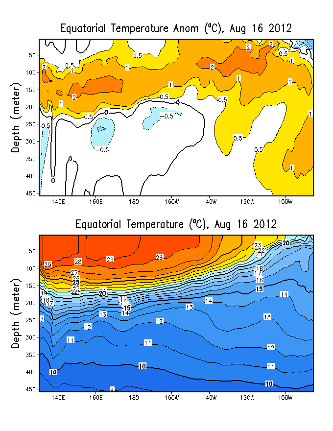
Also if we take a look at the latest SUB SURFACE SSTAs in the El Niño regions down to say 100-150 meters it certainly does look very impressive with the large pools of warm water. The first link is the current or latest graph dated November 24
http://www.cpc.ncep.noaa.gov/products/analysis_monitoring/enso_update/sstxz.gif
What's important to note is how the large pool the very warm water are migrating eastward away from ENSO REGION 3.4 and headed towards the coast of Peru. And second the increasing pool of cool SSTA which has developed in the western Pacific just over the international dateline. Again this pool of cooled water has increased dramatically over the last few weeks. The what this data is telling me is that be of El Nino is close to peaking and that those who think the Lower Moderate El Nino is going to continue with no change in strength right to into January (which would greatly increase the chances are seeing a mild winter east of the Rockies) should be very nervous right now.
Lastly lets talk about the new QBO value for November which drop slightly to very close to 10.00. http://www.cdc.noaa.gov/Correlation/qbo.data
As I mentioned in the winter forecast discussion the cycle all a positive QB O phase runs anywhere from 10 to 13 months... from neutral to the zenith back to neutral. AS I said in the Winter forecast the key feature in opinion was going to be what the NOV and DEC 2006 values and whether the drop-off begins in December. I have held all along that the second half of this Winter is when things will get active with regard to snowfall storminess and cold temperatures over the central and eastern US. A drop-off in the QBO into the single digits...say +8 or +6 ... in DEC 2006 would greatly support that view.
However that being said I am noticing a NEW analog which of some folks appear to overlook and I would have to say that i have over looked it this analog as well.
This link is the CPC enso 3.4 values going back to 1950.
http://www.cpc.ncep.noaa.gov/products/analysis_monitoring/ensostuff/ensoyears.shtml
Take a look at the year 1957. Just like to Jan 2006 Jan 1957 started out with a weak La Nina... and the El Niño 3.4 that year reached values of 1.5 and 1.6 in DEC 1957 and JAN and FEB 1958.
The match also exists in the MEI values of late 1957 into 1958... where the MEI values held right around +1.0 to +1.14... and this again seems to be similar to what we are saying with the current MEI values
http://www.cdc.noaa.gov/people/klaus.wolter/MEI/table.html
Moreover if you take a look at the QBO values of 1957... into 1958 you'll see something quite remarkable. Note that during the OCT and NOV 1957 the positive QBO values stayed around +10... which is of course is very similar to what we have here in late 2006
http://www.cdc.noaa.gov/Correlation/qbo.data
Note that in early 1958 the QBO did drop to values of +5.35 and Lower.
These very striking matches between what we are saying here in late 2006 and 1957 --58 is current unusual with regard to analogs. We really don't see analog matching like that very often in all three categories. A don't know what it means and this is certainly not in guarantee but I think it'll early at take a panic button and the rise or a near perfect analog of 1957 - 58 which featured a very mild December in 1957 -- really has to be noticed.
It's pretty clear the data this morning that right through December 17 much of the CONUS is going to see temperatures either Above Normal or Much Above Normal. But that is of course after a cold start to the month... so with regard to the overall temperatures over many locations east the Mississippi River by the time we get to say December 18 --20 the monthly temperature anomalies won't be that high.
Of course that really doesn't help if you're in the Plains which are pretty much going to miss out on this next cold blast coming down so they are going start warming up a lot sooner than the areas east of the Mississippi River. On the other hand if one were to take a look at let's say the European ensemble mean day 12-15 you'll see very clear signs that some sort of Ridge is trying to redevelop over western Canada and the model is depicting a broad flat trough over the Great Lakes & Northeast. If that were in fact correct ( which I dont think it will be ) such a pattern would keep the warming out of the northeast quadrant of the conus.
I noticed that the weekly SSTA figure for ENSO 3.4 which came out on Monday generated very little reaction... even though 2 weeks ago it did. Why do you think that's the case? Because two weeks ago we mots of the CONUS east of the Rockies was very warm the surge in SSTAs in enso 3.4 supported those were mongering for the warmest winter of all time. So they took the rise in SSTA and ran with it for all it's worth. Of course the problem is that now they run into the defense which is shutting down the running game big-time... jesus I am now doing football analogies and I am probably sounding like JB....
The defense or the reality here is the fact that the SSTA's last week in this week in Enso 3.4 did NOT rise. DID NOT. In fact the +1.3 C figure for enso 3.4 has held steady now for the last three weeks. Those who continue to argue that the EL Nino is going to stay Moderate or will increase through DEC are essentially are going the analog with one of two late developing El Nino events... the 1991-92 El Nino and the 1994-95 El Nino. And in fact many forecasters had mentioned these two late developing El Niño events as reasonable analogs to what we are saying here in week 2006.
http://www.cpc.ncep.noaa.gov/products/analysis_monitoring/ensostuff/ensoyears.shtml
The problem is of course that with this new weekly reading of enso 3.4 s that again show g No rise in the enso 3.4 SSTA means the analog to 1991-92 El Nino is in deep doo doo. It simply is no longer a valid argument to make. The other El Nino analog which has to be look at carefully is the 1994-95 El Nino. In last week of November 1994 the enso 3.4 did reach +1.5c then held steady at 1.4 or 1.3 all the way through December and January and not surprisingly that was a very warm winter... and a below normal snowfall one as well. A strong case can be made that this is similar to we are saying right now but there are TWO problems here .... the SOI and the QBO valuea. In NOV 1994 the 30-day value was almost -7.0 ... and for half of the month it droped to -13.0! However the 30-day average for the SOI for NOV 2006 is approximately -2.0 .
With regard to the QBO the 1994-95 El Nino analog has a serious problem in that the QBO was strongly negative in the Summer and Autumn of 1994 ... which is the exact Opposite of what we are now seeing!!!. Yes I know some forecasters out there dont give the QBO any value but those are the same forecasters who called for 20 named TC this past hurricane season. Failing to learn from that disaster they now hold onto the 1994-95 analog for dear life as they again repeating the same mistakes... ignoring the massive Phase difference between the the QBO values of late 1994 into 1995 and what we are seeing now
Also if we take a look at the latest SUB SURFACE SSTAs in the El Niño regions down to say 100-150 meters it certainly does look very impressive with the large pools of warm water. The first link is the current or latest graph dated November 24
http://www.cpc.ncep.noaa.gov/products/analysis_monitoring/enso_update/sstxz.gif
What's important to note is how the large pool the very warm water are migrating eastward away from ENSO REGION 3.4 and headed towards the coast of Peru. And second the increasing pool of cool SSTA which has developed in the western Pacific just over the international dateline. Again this pool of cooled water has increased dramatically over the last few weeks. The what this data is telling me is that be of El Nino is close to peaking and that those who think the Lower Moderate El Nino is going to continue with no change in strength right to into January (which would greatly increase the chances are seeing a mild winter east of the Rockies) should be very nervous right now.
Lastly lets talk about the new QBO value for November which drop slightly to very close to 10.00. http://www.cdc.noaa.gov/Correlation/qbo.data
As I mentioned in the winter forecast discussion the cycle all a positive QB O phase runs anywhere from 10 to 13 months... from neutral to the zenith back to neutral. AS I said in the Winter forecast the key feature in opinion was going to be what the NOV and DEC 2006 values and whether the drop-off begins in December. I have held all along that the second half of this Winter is when things will get active with regard to snowfall storminess and cold temperatures over the central and eastern US. A drop-off in the QBO into the single digits...say +8 or +6 ... in DEC 2006 would greatly support that view.
However that being said I am noticing a NEW analog which of some folks appear to overlook and I would have to say that i have over looked it this analog as well.
This link is the CPC enso 3.4 values going back to 1950.
http://www.cpc.ncep.noaa.gov/products/analysis_monitoring/ensostuff/ensoyears.shtml
Take a look at the year 1957. Just like to Jan 2006 Jan 1957 started out with a weak La Nina... and the El Niño 3.4 that year reached values of 1.5 and 1.6 in DEC 1957 and JAN and FEB 1958.
The match also exists in the MEI values of late 1957 into 1958... where the MEI values held right around +1.0 to +1.14... and this again seems to be similar to what we are saying with the current MEI values
http://www.cdc.noaa.gov/people/klaus.wolter/MEI/table.html
Moreover if you take a look at the QBO values of 1957... into 1958 you'll see something quite remarkable. Note that during the OCT and NOV 1957 the positive QBO values stayed around +10... which is of course is very similar to what we have here in late 2006
http://www.cdc.noaa.gov/Correlation/qbo.data
Note that in early 1958 the QBO did drop to values of +5.35 and Lower.
These very striking matches between what we are saying here in late 2006 and 1957 --58 is current unusual with regard to analogs. We really don't see analog matching like that very often in all three categories. A don't know what it means and this is certainly not in guarantee but I think it'll early at take a panic button and the rise or a near perfect analog of 1957 - 58 which featured a very mild December in 1957 -- really has to be noticed.
posted by DT @ 12/06/2006 12:11:00 PM
![]()

25 Comments:
At 1:16 PM, Anonymous said…
Good discussion...what did Jan/Feb/Mar of 1958 bring to the US?
At 2:19 PM, Anonymous said…
DT,
You noted that 1957-1958 had a very mild December on 1957. How did January and February of 1958 turn out?
At 2:20 PM, Anonymous said…
DT,
Great find with the 1957-58 analog. Was the storm in February that winter a miller a storm? Also, do you expect a greater chance of miller a storms due to the absence of hurricanes in the gulf?
At 2:25 PM, Anonymous said…
You been pimping the comments @ Foot's Forecast?
At 2:32 PM, Anonymous said…
JB sez that if the Aggies win enough games, cold and snow for I95 right around the corner! LOL
At 2:55 PM, Anonymous said…
Yeah sure the weenies at eastern have outlooks . . .weenies always have outlooks because not a damn thing goes into them. Always takes more skill to cook a real meal than roast a weenie. So STFU and when DT is ready offer a professional opinion he will.
--------------------
God, you are an annoying douchebag..drop dead already.
At 3:16 PM, Anonymous said…
I'd love to see that '57-'58 analog. We got nearly 42" in Philly. That makes me feel better about my 30-40".
It's amazing that I'm getting e-mails asking if I'm going to revise my forecast. It's barely December!
Glenn
At 4:00 PM, Anonymous said…
So how did January and February of 1958 end up?
At 4:10 PM, DT said…
hey Glenn....
I am not surprisie about the emails and calls ... if you are not with consensus ... what that happens to be,... politics or who will win the super Bowl... folks get upset
At 4:30 PM, Anonymous said…
For all his faults, DT is still one of the most accurate forecasters on the planet and I take his forecasts with a much higher degree of seriousness than many others. However, he's up to his old tricks this year in that he is repeatedly making it sound like he's the only one expecting it to be colder and snowier than average in the east, when in fact it's primarily NOAA that has a warm outlook. There are a great deal of winter outlooks that believe we're in for a very rough stretch (cold/snow) once past December. However, DT is already gearing up to be in a position to claim that only he got the winter outlook right (pure DT and pure BS). Having said all that, I am encouraged that he is reinforcing his belief that an active winter is indeed on the way.
At 5:28 PM, DT said…
I guess I should be happy about part of what you said but really thie poster " FOR ALL HIS FAULTS DT..' is a true Ignoramous.
First I have NOT called for a winter colder and snowier than Normal east of the Mississipi or in the Northeast. ALL I have said is colder than EXPECTED
Second for this guy to assert that ONLY NOAA/ CPC is calling for a Mild winter is well wrong? Look anonymous poster just b/c YOU dont know of the numerous other seasonal forecasts that are out there calling for a Milder than Normal El Nino like winter does NOT mean these forecasts dont exist!!!
MILDER THAN NORMAL
CPC
weather 2000
EATHSAT
FREESE NOTIS
SEMPRA ENERGY
WEATHER TRADES
WSC
just to name a few....
and over at eastern almost every Met there besides HM and myself.
I wish Just one time a weenie would ask a question first instead of making a false assertion that is well bullshit. If the poster had said "DT why do you keep saying that most forecasts for this winter are calling for milder than Normal ? who are they?..." THAT would be just fine.
Instead this asshole weenie attacks my character and accuses ME of of some sort of political spin or some sort of god dam conspiracy.
If this asshole poster had ANY integrity he would apologize
At 5:45 PM, Anonymous said…
Hey DT,
The subsurface stuff at the TAO/TRITON stuff is more recent and still tells the story you are telling:
http://www.pmel.noaa.gov/tao/jsdisplay/
(click on assorted plots button up top)
Remember, while my EarthSat group is overall milder than normal (but still 5% colder than 05-06), I'm still on the colder side of the 30Y fence personally. I agree that the El Nino will need to wane in Dec to get us there.
MR
At 9:49 PM, Anonymous said…
RAY- DT, no offense, but there are plenty of mets other than HM forecasting cold winters at eastern. In fact, the vast majority are going a little colder than avg. in the east. If you were talking nationally, than I apologize in advance. There are plenty of warm forecasts for the nation as a whole, but the conscensus of pro mets at Eastern is decidedly cold in the east.
At 8:14 AM, DT said…
RAY
Of course I was and I am talking nationally. Contrary to popular belief there is a weather world outside of eastern
At 9:12 AM, Anonymous said…
RAY
Of course I was and I am talking nationally. Contrary to popular belief there is a weather world outside of eastern
-
there is? News to me and the 25,000 14 yr old weenies over at that rathole of a site.
At 10:01 AM, Anonymous said…
http://www.noaanews.noaa.gov/stories2006/s2753.htm
NOAA says the El Nino is getting stronger. I'm not sure what to believe .
At 10:24 AM, DT said…
I didnt say the El Nino is weakening YET -- I am arguing it has reahed its zenith and there are indications that it will BEGIN to weaken later.
also keep in mind CPC is always a day late and dollar short with El nino/La Nina events. Keep in mind their defintion requires El nino / La Nian conditions be present for 3 months BEFORE it is declared "officially"
They missed the El Nino rise back in AUG an the end of the La Nina in March
At 10:40 AM, Anonymous said…
what this data is telling me is that be of El Nino is close to peaking and that those who think the Lower Moderate El Nino is going to continue with no change in strength right to into January (which would greatly increase the chances are seeing a mild winter east of the Rockies) should be very nervous right now.
--------------------------------------
Thanks... if I was paying attention it is right there in black and white.
At 1:29 PM, Anonymous said…
RAY- I love fu***ng idiots who don't have the balls to criticize someone from underneath the "anonymous" vale! Please remove the anonymous underwear and reveal the pu**y that you are if you would like to insult me. Apparently you are suffering from a paucity of reading comprehension skill becaue I offered an advanced apology, in fact realizing that "there is a world other than the east coast", which is why even DT himself did not bash me a**whole! Sometimes there are miscommunications in one's haste to type.
At 5:54 PM, Anonymous said…
i laugh when people put dt down. whether people want to admit it or not he is very good at what he does. i remember dave from njwo years ago and he's a good man although there are times he can go over board a little every man has his faults. i think people should look at his forecast with there eyes open,"colder then last year".dave is doing a fine job this year on his pattern updates.if you dont like what he says then goe else where. the man puts a free sight out for people to read and he's an expert at what he does.
At 6:42 AM, Anonymous said…
Hey Glen and Dave Dave I disagree with anonymous your last years forecast was great. As JB would say you cleaned his clock. I tell my brother Henry Margusity to read your blog.Glenn I shared your forecast with him and he thought you were right on this year.
At 11:48 AM, Anonymous said…
DT, it's entertaining to watch many of the weenies over at eastern on suicide watch because of the current unfavorable pattern in the east. What most seem to forget is that even the awesome winter of '93-94 (at least it was awesome in east PA) did not really get rolling until January of 94. In fact, if memory serves me well, there was quite an eastern blow torch in the middle of dec. 1993.
Good luck with discerning where this pattern is going. I look forward to more of your analysis.
John in PA
At 12:23 PM, Anonymous said…
Hey Glen and Dave Dave I disagree with anonymous your last years forecast was great. As JB would say you cleaned his clock. I tell my brother Henry Margusity to read your blog.Glenn I shared your forecast with him and he thought you were right on this year.
-
Margusity should read the blog...maybe he would learn something about winter forcasting...right now, he's the worst out there, just waffles in the wind with each model run.
At 3:54 PM, Anonymous said…
Had to chime in on this one... I have occasionally had some issue with DT - and he probably knows what most of them are since we've spoken many times. And I'm not keen on his acidic responses, but his analysis here is excellent and deserves only praise. Ironically, I conducted an identical analysis at my job just the day before DT posted this analysis and came up with an identical result. The only complaint I'd have about DT's analysis is a lack of focus on the PDO. But, guess what, that matches 1957-58 almost perfectly as well (weakly negative). The only other similar analog I found was 1965-66. Simple fact is, if you have a complaint about DT, fine, make it where appropriate (and don't make it anonymous). Don't put it in this thread... this is one of the best analyses I've ever read by DT... not just because he agrees with me, but because it is complete and highly analytical (e.g., NOAA's new El Nino update seems to be completely oblivious to the cool sub-surface SSTs in the western Pacific). Excellent job, DT.
At 8:10 PM, Anonymous said…
I admit I am just a weenie.. and this might not be the right forum for this. But can someone tell me how NOAA can be completely oblivious to the cool sub-surface SSTs? To the less than trained eye..you look at how fast it came on and you would assume it will continue and peak in late winter. What is it that they are looking at that they don't think it has peaked yet?
Post a Comment
<< Home